

Touching the Promised Land 15 | Day 6 – THE JORDAN RIVER @ QASR EL-YAHUD
Updated: Aug 16
WATERS DESCENDING TO RISE
Departing Jericho, the original itinerary had us heading directly for the Qumran Caves, but my guide strongly proposed a detour to Qasr el-Yahud.
He was convinced that, given my expressed interest in the River Jordan (I surely must have asked a lot of questions, maybe, haha…), and my visit just a few hours earlier to Al-Maghtas on the eastern bank under the care of my Jordanian guide, it would be immensely worthwhile to make a quick and convenient stop on the western side of the river as well.
I must admit, I did not entirely follow his reasoning at the time; it occurred to me that if our schedule allowed room for an impromptu detour, why on earth weren't we taking the cable car in Jericho to see the Monastery of the Temptation instead? Yet, before we could even conclude our discussion, our driver was already pulling into the car park at Qasr el-Yahud. It was indeed, just as the guide had promised, very close and entirely on our way. And so, there we were, standing on the western bank of the legendary Jordan.

Highlights
1. The river: Compared to the great rivers of the world—the Nile stretching some 6,700 kilometres, the Yangtze 6,300, or the Euphrates 2,800—this river, with a total length of barely 250 kilometres, might well be considered miniature. Yet in renown, it stands second to none.
This is not merely because the Jordan flows through the Great Rift Valley, occupying the most tectonically active zone and marking the lowest elevation of any river on earth. It is also because of the divine miracles and sacred history it has witnessed over millennia, alongside the modern-day standoffs, rivalries, compromises, and yearnings for hope played out across its waters and along its banks.
The Jordan finds its source on Mount Hermon, which marked the northern boundary of Israel during the days of Moses (Deuteronomy 3:8) and whose name in Hebrew means "sacred mountain". Abundant in its upper reaches, the river flows down through the Hula Valley (formerly Lake Hula) before emptying into the Sea of Galilee; while emerging from the southern end of the lake, the lower Jordan meanders gently southward until it finally dissipates into the Dead Sea.

2. Scriptural and historical significance: In the Chinese Union Version of the Bible, the river is rendered as Yuedan He (约但河). It served as the primary eastern border of the Promised Land for the Israelites, God’s chosen people.
In the days of Abraham, the plain of the Jordan was well watered everywhere, "like the garden of the Lord" (Genesis 13:10). It was by the Jabbok, a tributary of the Jordan, that the grandson of Abraham, Jacob, wrestled with God until the breaking of the day on his return to the Promised Land, receiving the name "Israel" (Genesis 32:28).
Before his earthly ministry closed, Moses ascended Mount Nebo, casting his eyes westward to gaze upon the Jordan Plain, the Land of Milk and Honey that God had blessed to Israel (Deuteronomy 34:1–4). Later, under Joshua’s leadership, the Israelites crossed the Jordan as the waters parted to reveal dry ground, permitting the entire nation to pass safely into the Promised Land (Joshua 3:7–17).
It was also here that John the Baptist preached, administering the baptism of repentance, and where he baptised our Lord Jesus (Mark 1:9, among other passages).
3. Two banks, one horizon: The site I visited that morning, Bethany Beyond Jordan, under the guidance of my Jordanian host, takes its name from the Gospel of John: "These things took place in Bethany across the Jordan, where John was baptising" (John 1:28). In 2015, it was inscribed as a UNESCO World Heritage site and is widely recognised as the authentic location of Christ's baptism. Meanwhile, Qasr el-Yahud, now recommended by my Israeli guide, has long been the traditional pilgrimage site for the baptism on the West Bank.
The name Qasr el-Yahud is an Arabic transliteration meaning "Castle of the Jews" (or "Palace of the Jews"), while the name Al-Maghtas means “Baptism”. Inevitably, some friction and competition exists between the two sites, as heard from both my Jordanian and Israeli guides.
Qasr el-Yahud and Al-Maghtas are collectively held to be the traditional site where Joshua led the Israelites across the Jordan to enter the Promised Land and march upon Jericho. It is also revered as the site of the Prophet Elijah’s translation—Tell Mar Elias, located within Al-Maghtas on the eastern bank, is traditionally identified as the spot from which Elijah ascended to heaven in a whirlwind.
4. Administration: Geographically, Qasr el-Yahud lies within the Jericho Governorate of Palestine, much like the city of Jericho we had just departed. However, unlike Area A under Palestinian control, this area is managed by the Israeli Civil Administration and the Ministry of Tourism as part of an Israeli national park.
Following UNESCO's decision to list the eastern bank (rather than both sides) as the official World Heritage site, a number of fine new churches have been erected on the Jordanian side.

Sightseeing Notes
Until Qasr el-Yahud, my itinerary had traced the River Jordan longitudinally: I spent my first night in the Holy Land at Tiberias on the shore of the Sea of Galilee (the lake connecting the upper and lower streams), rested on the fifth night by the Dead Sea on the Jordanian side (the river's terminal point), and had even taken a detour past the Gulf of Aqaba (where the Great Rift Valley extends southward into the Red Sea). On this particular day near Jericho, however, we were able to contemplate this river latitudinally, looking across from both sides of the same bank at Qasr el-Yahud and Al-Maghtas.
Early October marks the tail-end of the dry season, when the Jordan falls to its lowest level. (When we visited the Church of the Primacy of St. Peter on the shores of Galilee, our guide noted that the lake's water levels were at historic lows, desperately requiring replenishment). Being at the absolute terminus of the lower Jordan, the water volume at Qasr el-Yahud and Al-Maghtas was diminished further still—exceptionally shallow and distinctly turbid. Indeed, the ancient baptismal pools I saw at Al-Maghtas in the morning were entirely parched.

During the rain-abundant winter months, however, these historic pools fill with water.

As far as modern-day baptismal sites are concerned, whilst both Qasr el-Yahud and Al-Maghtas are open to the public for visitation and baptisms, there are far fewer baptismal candidates than at Yardenit in Israel—as noted by my Israeli guide. Yardenit is situated further north, near where the Sea of Galilee flows into the Jordan; there, the water runs clearer, and the facilities for services, changing, viewing, and fellowship are far more comprehensive.
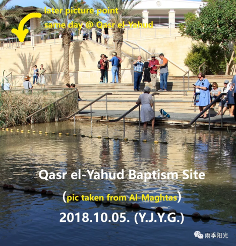
Though I knew intellectually that Qasr el-Yahud was close to Al-Maghtas, it was only when I sat on the steps leading down to the riverbank at Qasr el-Yahud, looking directly across at the Greek Orthodox Church of St. John the Baptist, that I realised the sheer proximity. I suddenly realised that a mere three hours prior, I had been standing on the wooden jetty indicated by the yellow arrow in the picture below. It felt quite surreal, as if stepping through time...

Conversely, looking back at the photo I took of the "opposite bank" while visiting Bethany Beyond Jordan a few hours earlier, I was actually looking at Qasr el-Yahud (unbeknownst to me at the time, as my Jordanian guide had not mentioned it). In that picture, I can even pinpoint the exact steps where I later sat to take the previous photo above.
This stretch of the Jordan was once a heavily fortified frontline between Israel and Jordan following the Six-Day War, surrounded by minefields to secure the border. The signing of the peace treaty in 1994 and the subsequent establishment of diplomatic relations led to the clearing of these mines, making archaeological excavations possible and sparking a rapid expansion of tourism on both banks.
Yet, over recent decades, intense competition for the water resources of the Jordan and its tributaries among Israel, Jordan, and Syria has not only fueled regional tensions but has also drastically depleted the flow of this ancient, holy river. Consequently, the Jordan has been designated as one of the world's top 100 most endangered ecological zones.
As I stood there, looking out between the two baptismal facilities facing one another across the narrow, muddy channel, the two lines of yellow floating buoys serving as a "Do Not Cross" warning and the signs on the railings reading "Border Ahead" served as stark reminders of how unusual this waterway is. They speak of past conflicts and unresolved rivalries. One could not help but offer a heartfelt prayer, asking our Heavenly Father to grant lasting peace to this river. Amen.

If I Had More Time
Given that this itinerary was designed primarily as a flying visit, I am broadly content with my Jordan-side arrangements. The temporarily added stop at Qasr el-Yahud proved immensely meaningful.
Should I find myself with a more generous allowance of time in the future—and assuming my enthusiasm for natural landscapes, outdoor trekking, and scriptural and historical overviews remains undiminished—I might well consider a dedicated outdoor itinerary focusing exclusively on the Jordan, tracking its course all the way from Mount Hermon to the Dead Sea.
Touching the Promised Land 16 | Day 6 – QUMRAN
THE HIDDEN CLIFFS AND SACRED TRUTH
With a final look at the narrow, historic boundary of the Jordan, we climbed back into the car to return to our original itinerary. The valley of the river soon gave way to the stark, sun-bleached desert of the Dead Sea basin. A short drive brought us to the limestone cliffs of Qumran, get us ready to explore the ancient caves whose hidden secrets would provide an irrefutable textual witness to the accuracy and authenticity of the Bible throughout millennia of transmission.
